On The Mountain: Gorgonio
 | The peak of San Gorgonio Mountain (also known as "Old Greyback") is the highest point in southern California, and I hiked to the top of it yesterday. Our party consisted of me, Kath, Kath's sister Suzanne, and Andrew, and we moved FAST. The conditions were just about perfect on the Vivian Creek trail. The day was sunny, but with a cool breeze. The trail was bone dry, without the leg-killing snow that brought me low last time. |
The trailhead starts at Forest Falls, a small community at the border of the San Gorgonio wilderness. The site has a good description of some of the major trails in the wilderness. The Vivian Creek trail was crowded for us. A good succinct description of the trip can be found here. Another account of a hike is here. He reported an approximate distance of seven miles to the peak, which seems a bit shorter than I measured.
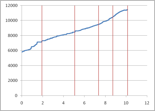
The trail was like five hours on a Stairmaster: It went UP. It began with a series of switchbacks that rocketed us up from the dry riverbed. The last miles were up an exposed stone bowl to the final ridge, often covered with snow, and I thank Kath for pulling me up the hill. The elevation map below shows the altitude gain over the hike, with the vertical lines marking the hours of our trip up. (I calculated a somewhat longer distance than reported by other references, possibly because my analysis included elevation changes. Also, I also used the Haversine formula to correct for the curvature of the earth, which may be overkill for small differences. Or, most likely, because of errors in GPS readings in some spots?)
The trip down was about four hours, I think. (Unfortunately, I didn't time it.) I was pretty tired out, with my legs and feet burning. Some of the spots on the trail, in particular the final switchbacks by the dry creek, were so steep (and dusty) that we had to tread carefully lest we start sliding.
It was a beautiful day, the trail had amazing views, and it felt great to stand at the top.
On the map below, the blue line shows our path. Click on the camera icons to show pictures and description. Unfortunately, the map may be shifted around, but it can be panned back into place like any other Google Map.
This is a link to the hike KML file, which can be viewed in applications like Google Earth.
Comments
Well Jeff, it's not Blue Mountain in the Adirondacks but it is impressive. I love the audio visual effects and the maps etc. Do I understand that it took you 10 hours to climb this ridge? That seems excessive when one of your pictures says you were 5.5 mi along after two hours. Maybe I am reading the graph wrong or the formula you used corrected for the curvature of Jupiter and not Earth.
Posted by: Tom Standing | May 29, 2007 09:53 AM
Tom - Oddly enough, I didn't label the axes on the graph above. The x-axis is distance in miles, the y-axis is elevation in feet. The red vertical lines are the hour markers, i.e. after one hour we had gone about two miles and 1000 ft up.
Posted by: Jeff | May 29, 2007 12:51 PM
is it true the girls beat the boys up the mountain
Posted by: Rich Baruch | May 29, 2007 05:10 PM
Rich - I can't speak for Andrew, but the sisters kicked my butt, at least.
Posted by: Jeff | May 29, 2007 08:35 PM